


Well Springs Voting District, Campbell County, Tennessee
About
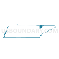
Outline

Summary
| Unique Area Identifier | 668026 |
| Name | Well Springs Voting District |
| County | Campbell County |
| State | Tennessee |
| Area (square miles) | 14.24 |
| Land Area (square miles) | 12.95 |
| Water Area (square miles) | 1.29 |
| % of Land Area | 90.92 |
| % of Water Area | 9.08 |
| Latitude of the Internal Point | 36.42933680 |
| Longtitude of the Internal Point | -83.93348600 |
Maps


Graphs
Select a template below for downloading or customizing gragh for Well Springs Voting District, Campbell County, Tennessee


Neighbors
Neighoring Voting District (by Name) Neighboring Voting District on the Map
- 5-10 Sharps Chapel Elementary Voting District, Union County, TN
- 5-13 Bradens School House Voting District, Union County, TN
- Clairfield Voting District, Claiborne County, TN
- Coolidge Voting District, Campbell County, TN
- Habersham Voting District, Campbell County, TN
- Rogers Mill Voting District, Claiborne County, TN
- Valley View Voting District, Campbell County, TN
Top 10 Neighboring County Subdivision (by Population) Neighboring County Subdivision on the Map
- District 1, Campbell County, TN (8,795)
- District 5, Campbell County, TN (7,566)
- District 8, Claiborne County, TN (2,978)
- District 5, Union County, TN (2,243)
- District 9, Claiborne County, TN (936)
Top 10 Neighboring Unified School District (by Population) Neighboring Unified School District on the Map
- Campbell County School District, TN (40,716)
- Claiborne County School District, TN (32,213)
- Union County School District, TN (19,109)
Top 10 Neighboring State Legislative District Lower Chamber (by Population) Neighboring State Legislative District Lower Chamber on the Map
Top 10 Neighboring State Legislative District Upper Chamber (by Population) Neighboring State Legislative District Upper Chamber on the Map
Top 10 Neighboring 111th Congressional District (by Population) Neighboring 111th Congressional District on the Map
Top 10 Neighboring Census Tract (by Population) Neighboring Census Tract on the Map
- Census Tract 9501, Campbell County, TN (3,274)
- Census Tract 9509, Campbell County, TN (2,999)
- Census Tract 9705, Claiborne County, TN (2,876)
- Census Tract 9508, Campbell County, TN (2,374)
- Census Tract 403, Union County, TN (2,366)
- Census Tract 9704, Claiborne County, TN (936)